
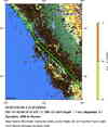
Magnitude 4.1 - NORTHERN CALIFORNIA
2011 January 08 00:10:16 UTC
Earthquake Details
- This event has been reviewed by a seismologist.
| Magnitude | 4.1 |
|---|---|
| Date-Time |
|
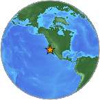
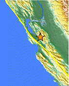
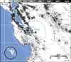
| Location | 37.288°N, 121.663°W |
| Depth | 7.1 km (4.4 miles) |
| Region | NORTHERN CALIFORNIA |
| Distances |
|
| Location Uncertainty | horizontal +/- 0.1 km (0.1 miles); depth +/- 0.3 km (0.2 miles) |
| Parameters | Nph= 97, Dmin=3 km, Rmss=0.06 sec, Gp= 68°, M-type=regional moment magnitude (Mw), Version=5 |
| Source | |
| Event ID | nc71506865 |
- Did you feel it? Report shaking and damage at your location. You can also view a map displaying accumulated data from your report and others.
Earthquake Maps
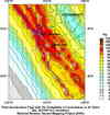
Scientific & Technical Information

.gif) Historic Moment Tensor
Solutions
Historic Moment Tensor
Solutions Tsunami
Information
Tsunami
Information
The earthquake locations and magnitudes cited in NOAA tsunami statements and bulletins are preliminary and are superseded by USGS locations and magnitudes computed using more extensive data sets.
