
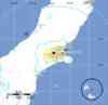
Magnitude 7.0 - SOUTH ISLAND OF NEW ZEALAND
2010 September 03 16:35:46 UTC
Earthquake Details
- This event has been reviewed by a seismologist.
| Magnitude | 7.0 |
|---|---|
| Date-Time |
|
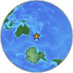
| Location | 43.530°S, 172.120°E |
| Depth | 5 km (3.1 miles) set by location program |
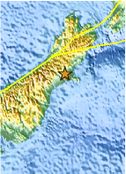
| Region | SOUTH ISLAND OF NEW ZEALAND |
| Distances | 45 km (30 miles) W of Christchurch, New Zealand 200 km (125 miles) SSE of Westport, New Zealand 290 km (180 miles) NNE of Dunedin, New Zealand 330 km (205 miles) SW of WELLINGTON, New Zealand |
| Location Uncertainty | Error estimate not available |
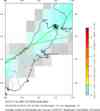
| Parameters | NST=374, Nph=374, Dmin=88.7 km, Rmss=0 sec, Gp=
18°, M-type=centroid moment magnitude (Mw), Version=9 |
| Source |
|
| Event ID | us2010atbj |
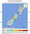
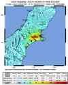
- Did you feel it? Report shaking and damage at your location. You can also view a map displaying accumulated data from your report and others.
Earthquake Summary
Tectonic Summary
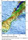
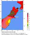
The September 3, 2010 South Island, New Zealand earthquake occurred as a result of strike-slip faulting within the crust of the Pacific plate, near the eastern foothills of the Southern Alps at the western edge of the Canterbury Plains. The earthquake struck approximately 50 km to the west-northwest of Christchurch, the largest population center in the region, and about 80-90 km to the south and east of the current expression of the Australia:Pacific plate boundary through the island (the Alpine and Hope Faults). The earthquake, though removed from the plate boundary itself, likely reflects right-lateral motion on one of a number of regional faults related to the overall relative motion of these plates and may be related to the overall southern propagation of the Marlborough fault system in recent geologic time.
The September 3, 2010 earthquake occurred approximately 50 km to the southeast of a M7.1, surface-rupturing event in Authur's Pass, on March 9th, 1929, which caused damage but injured no one. More recently, two earthquakes of M6.7 and M5.9 occurred in June 1994 approximately 40 km to the northwest of the 2010 event, but did not cause any known fatalities or significant damage.
Earthquake Information for New Zealand
Eastern Margin of the Australia Plate: Seismicity of the Earth 1900-2007, PDF
Earthquake Maps

Scientific & Technical Information

- Preliminary Earthquake Report
- U.S. Geological
Survey, National Earthquake Information Center:
World Data Center for Seismology, Denver
