 |  |
| (Station Photograph - click to enlarge) | (Sensor Layout - click to see PDF File) |
| CESMD |
| Information for Strong-Motion Station |
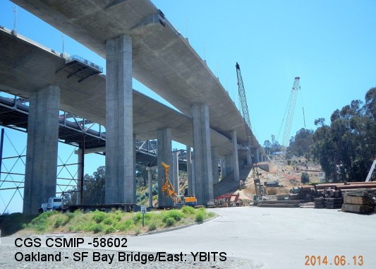
| Oakland - SF Bay Bridge/East: YBITS |
| CGS - CSMIP Station 58602 |
| Earthquakes recorded by this station |
| |
| (Station Photograph - click to enlarge) | (Sensor Layout - click to see PDF File) |
| Latitude | 37.8126 N |
| Longitude | 122.3627 W |
| Elevation (m) | 16 |
| Site Geology | Shallow alluvium/fill over rock (sedimentary) |
| Vs30 (m/sec) | - - |
| Site Class | |
| Remarks/Notes | Site information sources |
| No. of Spans | 9 |
| Plan Shape | Curved |
| Total Length | 461.3m (west bound); 448.8m (east bound) |
| Width of Deck | 27.161m(west bound); 27.169m plus 5.8m bikepath (east bound) |
| Construction Date | 2013 |
| Instrumentation | 2014. 23 accelerometers and 2 relative displacement sensors on the bridge plus 3 accelerometers at a reference free-field site (CSMIP sta. 58605). |
| Superstructure Type | Cast-in-place concrete box girders supported by concrete columns. The superstructure is divided into 2 frames with hinges. The first frame consists of four spans on 2-column outrigger bents (WB) or 1-column bents (EB). The second frame is supported on elongated single column bents. |
| Substructure Type | Concrete columns. 1 or 2 columns per bent. Maximum column height is 51 m at Bent W4. |
| Foundation Type | Concrete pile caps with CIDH concrete piles or steel piles in groups. Pile tip elevation ranges from -18m to 32m. At Bents W3 and W4L, the pile caps are anchored to rock with tiedowns. |
| Remarks | The new East Span opened to traffic on September 2, 2013. The Yerba Buena Island Transition Structure (YBITS) was instrumented during construction under the interagency agreement between Caltrans and DOC. |