
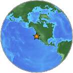
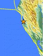
Magnitude 4.4 - OFFSHORE NORTHERN CALIFORNIA
This webpage has been replaced by a new version and will be phased out in the future. Please use our new Real-time Earthquake Map
to access the latest earthquake information and event details. The
links to the World, US, and CA/NV maps that were in the navigation on
the left side of the page have been replaced by the links at the top of
the new Map. The Real-time Earthquake Map User Guide describes how to use the map and all its features.
2012 July 08 12:05:48 UTC
Earthquake Details
- This event has been reviewed by a seismologist.
| Magnitude | 4.4 |
|---|---|
| Date-Time |
|
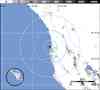
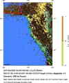
| Location | 39.480°N, 123.804°W |
| Depth | 8.1 km (5.0 miles) |
| Region | OFFSHORE NORTHERN CALIFORNIA |
| Distances |
|
| Location Uncertainty | horizontal +/- 0.5 km (0.3 miles); depth +/- 0.8 km (0.5 miles) |
| Parameters | Nph= 45, Dmin=23 km, Rmss=0.26 sec, Gp=173°, M-type=regional moment magnitude (Mw), Version=C |
| Source | |
| Event ID | nc71812891 |
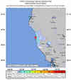
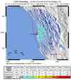
- Did you feel it? Report shaking and damage at your location. You can also view a map displaying accumulated data from your report and others.
Earthquake Maps

Scientific & Technical Information

 Historic Moment Tensor Solutions
 Tsunami Information
The earthquake locations and magnitudes cited in NOAA tsunami statements and bulletins are preliminary and are superseded by USGS locations and magnitudes computed using more extensive data sets.
