
Magnitude 5.9 - VIRGINIA
2011 August 23 17:51:03 UTC
Earthquake Details
- This event has been reviewed by a seismologist.
| Magnitude | 5.9 |
|---|---|
| Date-Time |
|
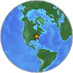
| Location | 37.975°N, 77.969°W |
| Depth | 1 km (~0.6 mile) (poorly constrained) |
| Region | VIRGINIA |
| Distances | 45 km (27 miles) E of Charlottesville, Virginia 55 km (34 miles) SW of Fredericksburg, Virginia 64 km (39 miles) NW of RICHMOND, Virginia 82 km (50 miles) NNE of Farmville, Virginia |
| Location Uncertainty | horizontal +/- 10.9 km (6.8 miles); depth +/- 7.4 km (4.6 miles) |
| Parameters | NST=390, Nph=390, Dmin=57.9 km, Rmss=1.17 sec, Gp=
47°, M-type=regional moment magnitude (Mw), Version=6 |
| Source |
|
| Event ID | usc0005ild |
- Did you feel it? Report shaking and damage at your location. You can also view a map displaying accumulated data from your report and others.
Earthquake Maps


 Tsunami
Information
Tsunami
Information
The earthquake locations and magnitudes cited in NOAA tsunami statements and bulletins are preliminary and are superseded by USGS locations and magnitudes computed using more extensive data sets.
General Tsunami Information
- Preliminary Earthquake Report
- U.S. Geological
Survey, National Earthquake Information Center:
World Data Center for Seismology, Denver
