
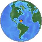
Magnitude 5.8 - PUERTO RICO
2010 May 16 05:16:10 UTC
Earthquake Details
| Magnitude | 5.8 |
|---|---|
| Date-Time |
|
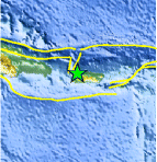
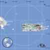
| Location | 18.400°N, 67.070°W |
| Depth | 113 km (70.2 miles) |
| Region | PUERTO RICO |
| Distances |
|
| Location Uncertainty | horizontal +/- 1.7 km (1.1 miles); depth +/- 1 km (0.6 miles) |
| Parameters | NST= 31, Nph= 31, Dmin=8.6 km, Rmss=0.27 sec,
Gp=104°, M-type=regional moment magnitude (Mw), Version=5 |
| Source | |
| Event ID | pr10136002 |
- This event has been reviewed by a seismologist.
- Did you feel it? Report shaking and damage at your location. You can also view a map displaying accumulated data from your report and others.
Earthquake Summary
Felt Reports
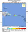
Minor damage to homes at Lares and Vega Baja. A landslide was reported at Utuado. Felt (V) at Adjuntas, Aguada, Anasco, Barranquitas, Jayuya, Lares, Las Marias, Maricao, Mayaguez, Moca, Morovis, Orocovis, Ponce, San German, San Sebastian, Utuado and Villalba. Widely felt in Puerto Rico and the eastern Dominican Republic. Also felt in the Virgin Islands.
Tectonic Summary
The Puerto Rico earthquake of May 16, 2010, occurred in an inclined seismic zone that dips south from the Puerto Rico Trench and that consists of subducted lithosphere of the North America plate. The broad-scale tectonics of the Puerto Rico region are determined by the motion of the Caribbean plate east-northeast at a velocity of about 20 mm/yr with respect to the North America plate. The North America plate is thrust beneath the Caribbean plate at the Puerto Rico Trench, and is seismically active to depths of about 150 km.
Earthquakes, such as this one, that have focal-depths between 70 and 300 km are commonly termed "intermediate-depth" earthquakes. Intermediate-depth earthquakes typically cause less damage on the ground surface above their foci than is the case with similar magnitude shallow-focus earthquakes, but large intermediate-depth earthquakes may be felt at great distance from their epicenters.
Earthquake Maps


Scientific & Technical Information

 Tsunami
Information
Tsunami
Information
The earthquake locations and magnitudes cited in NOAA tsunami statements and bulletins are preliminary and are superseded by USGS locations and magnitudes computed using more extensive data sets.
NOAA Tsunami Bulletins for this Earthquake
General Tsunami Information
- Preliminary Earthquake Report
- Puerto Rico Seismic Network, University of Puerto Rico
