
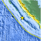
Magnitude 8.4 - SOUTHERN SUMATRA, INDONESIA
2007 September 12 11:10:26 UTC
Earthquake Details
| Magnitude | 8.4 |
|---|---|
| Date-Time |
|
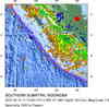
| Location | 4.520°S, 101.374°E |
| Depth | 34 km (21.1 miles) set by location program |
| Region | SOUTHERN SUMATRA, INDONESIA |
| Distances | 130 km (80 miles) SW of
Bengkulu, Sumatra, Indonesia 410 km (255 miles) SSE of Padang, Sumatra, Indonesia 625 km (385 miles) WNW of JAKARTA, Java, Indonesia 695 km (430 miles) SSW of SINGAPORE |
| Location Uncertainty | horizontal +/- 6.1 km (3.8 miles); depth fixed by location program |
| Parameters | Nst=286, Nph=286, Dmin=809.9 km, Rmss=1.11 sec, Gp=
29°, M-type=moment magnitude (Mw), Version=V |
| Source |
|
| Event ID | us2007hear |
- This event has been reviewed by a seismologist.
-
Did you feel it?
Report shaking and damage at your location. You can also view a map displaying accumulated data from your report and others.
Earthquake Summary

The following is a release by the United States Geological Survey, National Earthquake Information Center: An earthquake occurred 130 km (80 miles) SW of Bengkulu, Sumatra, Indonesia and 625 km (390 miles) WNW of JAKARTA, Java, Indonesia at 5:10 AM MDT, Sep 12, 2007 (6:10 PM local time in Indonesia). The magnitude and location may be revised when additional data and further analysis results are available. Earthquakes of this type sometimes cause tsunamis, however the USGS has no information that an actual tsunami has been generated. For information about tsunamis, contact the NOAA Tsunami Warning Centers at http://tsunami.gov.
Felt Reports
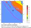
At least 25 people killed, 161 injured, 52,522 buildings damaged or destroyed and roads damaged in Bengkulu and Sumatera Barat. A tsunami with a wave height of 90 cm was measured at Padang. Power and telephone outages occurred. Felt by people in high-rise buildings at Jakarta and in Malaysia, Singapore and Thailand.
Tectonic Summary
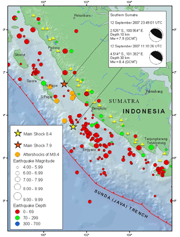
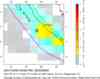
The magnitude 8.4 and 7.8 southern Sumatra earthquakes of September 12, 2007 occurred as the result of thrust faulting on the boundary between the Australia and Sunda plates. At the location of these earthquakes, the Australia plate moves northeast with respect to the Sunda plate at a velocity of about 60 mm/year. The direction of relative plate motion is oblique to the orientation of the plate boundary offshore of the west coast of Sumatra. The component of plate-motion perpendicular to the boundary is accommodated by thrust faulting on the offshore plate-boundary. Much of the component of plate motion parallel to the plate boundary is accommodated by strike-skip faulting on the Sumatra fault, which is inland on Sumatra proper.
The magnitude 8.4 earthquake of September 12, 2007 is the fourth earthquake of magnitude greater than 7.9 to have occurred in the past decade on or near the plate boundaries offshore of western Sumatra. This earthquake occurred just north of the source region of the magnitude 7.9 earthquake on June 4, 2000. The September 12, 2007 magnitude 7.8 earthquake occurred about 225 km northwest of the magnitude 8.4 earthquake at the northern end of the aftershock zone. These two earthquakes and their aftershocks overlay the southern portion of the estimated 1833 rupture zone, which extends from approximately Eggano Island to the northern portion of Siberut Island. The great magnitude 9.1 earthquake of December 26, 2004, which produced the devastating Indian Ocean tsunami of that date, ruptured much of the boundary separating the India plate and the Burma plate. Immediately to the south of the great 2004 earthquake, the magnitude 8.6 Nias Island earthquake of March 28, 2005, ruptured a segment of the plate boundary separating the Australia and Sunda plates. Since the December 26, 2004 earthquake, much of the Sunda trench between the northern Andaman Islands to Eggano Island, a distance of more than 2,000 km, has ruptured in a series of large subduction zone earthquakes.
Tectonic
Summary PDF
Modern
Ruptures PDF
Earthquake Information for Asia
Earthquake Information for Indonesia
 Tsunami Information
- West Coast & Alaska Tsunami Warning Center
- Pacific Tsunami Warning Center
The earthquake locations and magnitudes cited in these bulletins are very preliminary, and may disagree with the more accurate USGS locations and magnitudes computed using more extensive data sets.
- NOAA Tsunami Warning Center
- Recent Tsunamis
- Tsunami Information Links


.gif) Historic Moment Tensor Solutions
Historic Moment Tensor Solutions- Preliminary Earthquake Report
- U.S. Geological Survey, National
Earthquake Information Center:
World Data Center for Seismology, Denver
